MACHU PICCHU · OVERVIEW
Machu Picchu is a 15th-century Inca citadel located in the Eastern Cordillera of southern Peru on a mountain ridge at 2,430 meters (7,970 ft). It is situated in the Machupicchu District of Urubamba Province about 80 kilometers northwest of Cusco, above the Sacred Valley and along the Urubamba River, which forms a deep canyon with a subtropical mountain climate.
LOCATION ·
-13.16333, -72.54556
History
[ edit ] One of the first pictures of Machu Picchu, taken by Hiram Bingham III in 1912 after major clearing and before reconstruction work began Machu Picchu’s early chronology continues to be a matter of scholarly debate. Earlier chronological models, based mainly on John H. Rowe 's historical reconstruction of the reign of Pachacuti Inca Yupanqui, have placed the beginning of construction around 1450, 10 years after his takeover. However, a 2021 study led by Richard L. Burger , professor of anthropology at Yale University ), reporting 26 AMS radiocarbon measurements from human remains concluded that Machu Picchu was occupied from around 1420 to 1530. Similar conclusions supporting an earlier 15th-century chronology have been reported by other radiocarbon studies. Construction appears to date from two Sapa Incas , Pachacutec Inca Yupanqui (1438–1471) and Túpac Inca Yupanqui (1472–1493). A consensus among archaeologists is that Pachacutec ordered the construction of the royal estate after his conquest of the middle and lower Urubamba; this has been interpreted as part of a broader program of establishing royal estates along the Urubamba River. Machu Picchu’s palace complex is thought to have functioned as a seasonal royal retreat. Although Machu Picchu is considered to be a royal estate, it would not have been passed down in the line of succession . [ citation needed ] Rather, it was used for 80 years before being abandoned, seemingly because of the Spanish conquests in other parts of the Inca Empire . It is possible that most of its inhabitants died from smallpox introduced by travelers before the Spanish conquistadors even arrived in the area.
Excavations and controversy (1912–1915)
[ edit ] Route map of the 1912 Yale Peruvian Expedition, which carried out the first archaeological excavations at Machu Picchu. Bingham returned to Machu Picchu in 1912 under the sponsorship of Yale University and the National Geographic Society . The expedition conducted site clearing and archaeological work between July and November of that year, under the supervision of George Eaton and Ellwood Erdis. These efforts included burnings, vegetation removal, mapping, and excavations, many of which were carried out with the assistance of local labor organized in part by Ángel Lizárraga, younger brother of Agustín Lizárraga. The work was supported logistically by regional authorities, including the Prefect of Cusco. Excavations resumed in 1914 and 1915 during a subsequent expedition. Although Bingham proposed several hypotheses regarding the purpose and significance of the site, none have been substantiated by later research. During the expeditions, numerous artifacts were recovered and transported to Yale University. Among these was a set of 15th-century ceremonial Incan knives made from bismuth bronze , which are the earliest known artifacts to contain this alloy. Although local institutions initially welcomed the exploration, they soon accused Bingham of legal and cultural malpractice. Rumors arose that the team was stealing artifacts and smuggling them out of Peru through Bolivia . In fact, Bingham removed many artifacts, but openly and legally; they were deposited in the Yale University Museum. Bingham was abiding by the 1852 Civil Code of Peru; the code stated that "archaeological finds generally belonged to the discoverer, except when they had been discovered on private land". Local press perpetuated the accusations, claiming that the excavation harmed the site and deprived local archaeologists of knowledge about their own history. Landowners began to demand rent from the excavators. By the time Bingham and his team left Machu Picchu, locals had formed coalitions to defend their ownership of Machu Picchu and its cultural remains, while Bingham claimed the artifacts ought to be studied by experts in American institutions.
Later archaeological research and scientific studies
[ edit ] After Bingham's expeditions, state and institutional projects carried out mainly restoration and limited excavations between 1929 and 1971. From the 1970s to the 1990s, a series of targeted excavations and conservation programs recovered mainly Inca artifacts (ceramics, stone tools, and metal objects). They documented disturbed or reworked layers within the site. Between 2014 and 2017, the Archaeological and Interdisciplinary Research Program in the Historic Sanctuary of Machupicchu (PIAISHM) carried out systematic excavations, pollen studies , and architectural analyses that clarified construction phases, recorded offerings, and refined interpretations of its function and population. Radiocarbon dating analyses have refined the site's chronology, indicating that Machu Picchu’s main construction and use fall in the early to mid 15th century, slightly earlier than some traditional documentary chronologies suggest. Between 2017 and 2019, an international team led by Nicola Masini of Italy’s CNR investigated the Principal Plaza using archaeological, remote-sensing, and geophysical data. The study found that the area evolved from a natural drainage basin to a quarry before being reshaped with subsurface drainage. The plaza was likely built in at least two phases, beginning as a smaller sunken plaza (plaza hundida) that was later raised and expanded into the present ceremonial space. [ undue weight? – discuss ]
Construction
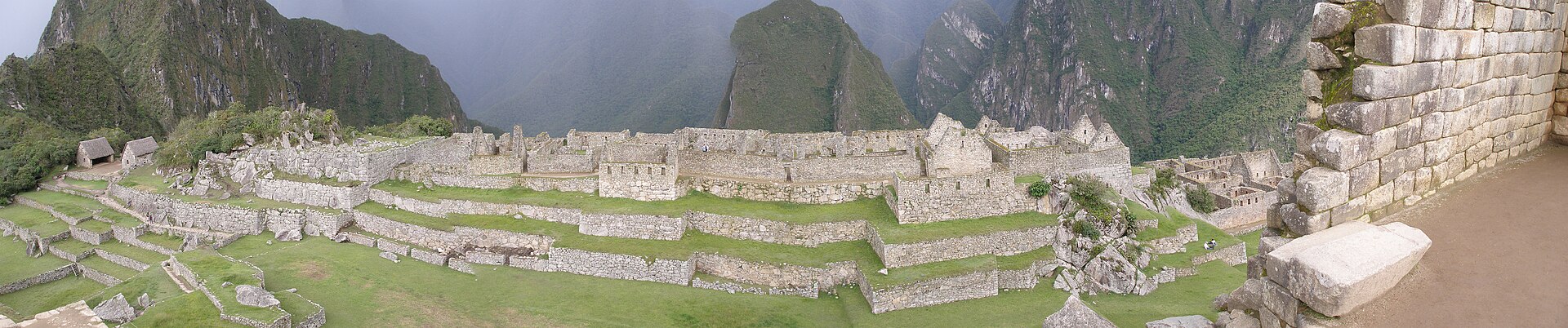
[ edit ] Main article: Incan architecture Residential section with closely joined stones typical of Inca dry masonry The central buildings of Machu Picchu are built in classical Inca dry masonry , with large blocks precisely shaped through quarrying , stone-cutting , and stone-dressing , then fitted together without mortar . The site may have been intentionally built on fault lines to provide natural drainage and a source of fractured stone for construction. According to geologist Rualdo Menegat, Machu Picchu "shows us that the Incan civilization was an empire of fractured rocks." Inca quarry at Machu Picchu, where large irregular granite blocks from a natural granitic chaos were used as building stone. The section of the mountain where Machu Picchu was built provided various challenges that the Incas solved with local materials. One issue was the seismic activity due to two fault lines, which made mortar and similar building methods nearly useless. Instead, the Inca mined stones from some quarries at the site, including one identified in 2023 using remote sensing techniques, which was probably located in the catchment area between the Hurin and Hanan before it was covered over to create the current Plaza Principal . Once mined, the Inca lined the granite stones up and shaped them to fit together perfectly, stabilizing the structures. Inca walls have many stabilizing features: doors and windows are trapezoidal, narrowing from bottom to top; corners are usually rounded; inside corners often incline slightly into the rooms, and L-shaped blocks are often tied together outside corners; walls are offset slightly from row to row rather than rising straight from bottom to top. Heavy rainfall required terraces to drain rainwater and prevent mudslides, landslides, erosion, and flooding. Terraces were layered with stone chips, sand, dirt, and topsoil to absorb water and prevent it from running down the mountain. Similar layering protected the large city center from flooding. Multiple canals and reserves throughout the city provided water that could be supplied to the terraces for irrigation and to prevent erosion and flooding. The approach to moving and placing the enormo